
Soberanes Canyon Trail, Garrapata State Park, California. Location of trailhead: Latitude 36.4387, Longitude -121.9203.

The signs at the trailheads in this region warn of mountain lions, rattlesnakes and poison oak. I seem to be impervious to the latter and am only exhilarated by the possibility of seeing the first two. I consider these types of signs to be more about the “best stuff to see” as opposed to any message of caution I should heed. A few years back, while hiking at Kenai Glacier in Alaska, I was amazed and amused by the bear warning signs posted by the National Park Service. Apparently, if at any times a bear “begins to feed on you”, you should “fight back”. Brilliant! To be fair though, the rest of the sign did give some pretty good advice as well as helpful information on the behavioral differences between black and brown bears.
Now, on the trails here in Central California, I did end up seeing one of those rattlesnakes. It was this past Easter, while on a hike through Garland Ranch Regional Park, in Carmel Valley. It was a small guy, for sure, but my very first rattler, so I was thrilled. Today, on the other hand, I had no such luck, but nonetheless was not left disappointed.
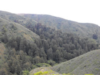
After leaving work at 5pm in Monterey, I headed down the PCH past Carmel Heights to a beautiful ocean overlook where the trailhead for Soberanes Canyon Trail begins. You enter Garrapata State Park as soon as you walk off the road, but this is evident only from a single sign post – there are no facilities or elaborate trail markers here. The trail winds up the canyon, following a stream along the way and , at this time of day, the air was buzzing with damselflies and stellar jays. After briefly passing through oak chaparral, the canyon winds through a valley of prickly pear cactus, through some riparian vegetation and then empties into a magnificent redwood forest a la the moon of Endor (minus any signs of Ewoks).
After spending some time among the redwoods, billows of fog began to roll in and the sky darkened with the approaching dusk. I had a mind to turn around, but noted that a few couples that passed me by while I stopped for photos had not come back this way. So, I guessed a loop trail and moved onward. I was greatly rewarded, as the best was yet to come. The trail eventually rises up from the redwood forest and onto the grassy slopes above tree line. From this vantage point, one can see how the redwood groves line the interiors of narrow canyons, and then quickly fade off as the slopes open up. The trail here rises high into the Santa Lucia Mountains, the slopes of which are alive with wildflowers at this time of the year. California poppies, composites and lupines were a few I recognized, but my recollection does not do them justice. It is a orgy of color up there and, as one climbs higher, a spectacular vista of the sea opens behind you, making the Pacific look like nothing more than a great, glassy pond.


Continuing upward, I feared that I had chosen wrongly as dusk settled deep on the backside of the mountain. But as I neared the summit, a still late afternoon sun greeted me, illuminating the rocky outcrops and flowered slopes in bright gold, scattered almost mystically through patches of fog. Although far above the sea now, the bellows of sea lions could yet be heard, their raucous barking radiating from an offshore pair of islets. I encountered a rabbit, a black-tailed deer and numerous western fence lizards.

The descent is on the front side of the mountain, exposed to the sun and ocean, so barren of trees. In one obscure spot, a carved bench sits on an outcropping. Through a friend I heard that on one night of every week, hikers meet here with bottles of wine to watch the sun go down. I had no wine, but the sun did set for me as I descended back down to the road. Funny, I kind of regret not having been caught up there past dark - I’d love to still be roaming those hills.


